23rd June 2013
Mile 864 to mile 872 : Sallie Keyes Lake to Vermillion Valley Resort
Mileage : 8 + 15
Today was the first time on the trail where I didn't feel like I was hiking the hike I wanted to hike. A phrase commonly heard on the trail is 'Hike Your Own Hike', meaning that there is no right or wrong way to hike, and also meaning that one hiker should not judge another should they being doing something different to oneself. I have decided that my hike will be a continuous hike from Mexico to Canada with a line of footprints to prove it, with probably over 99% on the PCT, but not all. I took a detour when I summited Mt Jacinto bypassing several miles of the official PCT in the process, but given the detour was longer and more arduous than the official trail, i didn't worry. Today we detoured around a section of the PCT in order to take a supposed shortcut to a popular hiking resort jsut off the trail called the Vermillion Valley Resort. The short called for us to take a side trail called the Bear Creek trail. We had had secondhand information that the trail wasn't too long, and was a descent for most of its length, so far so good. The problem was that no-one had a map or elevation profile for the trail, or knew where it ended, and if it did indeed end at VVR. I am generally comfortable navigating my way across and landscape with a map and compass, but without a map especially, I get uncomfortable. Especially given we didn't know how reliable the information was regarding the distance. Non-hikers as a rule do not estimate trail distances well, nor is it clear if times they quote to get from A to B are on foot or by car. The trail junction we intended to take was 8 miles into our day and at that point all was going well. As I we were all led to believe that the distance was not considerable, all of us put off eating lunch thinking we'd be eating real food at the resort in no time. So when we got to the junction we set off down it at speed. About 7.5 miles later we emerged at the other end of the trail. VVR was nowhere to be seen. All there was was a dusty car park with 2 or 3 pickup trucks for the day hikers we'd seen near the trailhead. The day hikers had confirmed that the resort was about 20 mins away, but again did not confirm by what mode of transport. It was buoyed by this news that we emerged at the carpark to find no resort. There was a map of the surrounding area at the trailhead which showed us where we were. It was still over 7 miles to the resort. Perfect. Knowing that we probably wouldn't be able to get rides with the day hikers, given how many we'd seen, we started off down the dirt road toward the resort. Before long we had joined a surfaced back country road with some traffic on it. Kat pretty much jumped infront of the first pickup truck that came past and it stopped. The driver was going past the resort and agreed to take us there. It was at this moment that I had to make a decision about my hike. Were I to have gotten the ride, I would have forfeited my continuous hike that I'd been so careful about up to now, but not getting the ride meant several more hours of hiking. It took a lot of willpower, but in the end i decided that retrospectively I would be more annoyed by not doing the hike, than I would be for doing it in the present. I watched the truck pull away wondering if i'd made another stupid decision that day. I ahd asked the driver how far it was to VVR from where we were, he'd replied '2 or 3 miles'. It wasn't, it was more like 6 from where we were. As I had thought it was so close, i hadn't bothered to fill up on water at the last creek crossing, and so was out of water. This wasn't really a problem like it was near Tehachapi, but it did mean i didn't really want to eat. Eating food without water when thirsty is difficult, so i trudged on not eating the food i knew was in my rucksack. With my low energy levels, given how little i'd eaten so far that day, the hike took a long time.
I was in a thoroughly bad mood during that hike, mostly with myself. I could have decided to carry on up the trail and take the more common detour like most people, but decided to follow the others without finding out whether or not they even intended to hike all the way there like I would have to. About half an hour after the truck pulled away, my day was changed for the better by a group of middle aged gents having their annual drinking weekend up in the mountains. They offered me water, soft drinks, beer and food without a second thought. A couple beers and a couple rounds of beer pong later, I was in a much better mood and continued up the road to VVR, finally arriving almost 3 hours after having watched the others depart in the pick up truck. I was glad to be done with the hiking.
Friday, 28 June 2013
Day 64 : The Californian halfway point
22nd June 2013
Mile 844 to mile 864 : Evolution Lake to Sallie Keyes Lake
Mileage : 20
Today I crossed the halfway point of California near mile 850. It is a daunting thought that I am only halfway through the first of three states, but it was a good feeling nontheless. The start of the day was lazy due to everyone needing to dry out sleeping bags which had collected a lot of condensation over night thanks to the proximity of Evolution Lake. Once we, and our equipment, had warmed up and dried off we set off down in Evolution Valley following the course of Evolution Creek. Just after the halfway point, we had to ford the sometimes infamous Evolution Creek. In high snow years, this ford can be extremely dangerous, with fast flowing icy water at chest height and sometimes requiring a group effort to get accross. In our low snow year though, the crossing didn't cause a concern for anyone and we all crossed with ease. There has been a lot of comment between hikers about the relative ease with which we have traversed the Sierras thus far, and feel I need to add my two cents. While it is true that we have not had to deal with deep snow or dangerous fordings this year, the trail has not been 'easy' this year. A high snow year in the Sierras means a high rain year for most, if not all, of the other sections of the trail. This has definitely not been the case this year. The temperatures have been far higher than average this year, and there has been far less water, requiring us to carry much more water that is usual. Another aspect which is absent in high rain/snow years is the fire danger. Yosemite national park has issued a total fire and smoking ban illustrating how worried they are about fire, even this early in the summer. So far this year there have been 2 fires on the trail, both fortunately behind me and therefore not requiring a detour, or an emergency evacuation. But I doubt this luck will continue, we'll have to see. The trail changes from year to year for a whole host of reasons, and this years challenge has been, and will continue to be, the heat and lack of water. Although a long way in the future, I am looking forward to northern Oregon and Washington where water ceases to be an issue. For the next couple hundred miles however, while we remain in the high mountains, I won't be stressing about water, except how cold it is whenever I have to ford a creek.
Towards the end of the day we had 200ft climb up towards Sallie Keyes Lake and Seldon pass, during which we passed a group of rangers. Within the the national parks and wilderness areas, all non natural modes of transport and motorised equipment is prohibited, and so this group, who were doing trail maintenance, came down the trail having had a hard day clearing huge trees of the trail with only 7 foot saws and huge heavy axes with which to cut the wood. It looked like a tough job, but they seemed like they were enjoying themselves as they came down the trail towards us. After a quick inspection of our bear canisters and permits, we carried on up to Sallie Keyes lake, just below Seldon pass, where we camped midst the hordes of mosquitoes. Luckily, mosquitoes don't seem to like the dark so we only had to endure them for an hour before they went to bed. We followed suit soon after the mosquitoes as we wanted to get an earlyish start so that we'd make it to Vermillion Valley Resort at a resonable hour the next day.
Day 63 : Muir Pass
21st June 2013
Mile 827 to mile 844 : Simpson Meadow Campground to Evolution Lake
Mileage : 17
Today was by far my best and favorite day on the trail. I was on form all day, and if at all possible, the scenery was even more stunning than the day before. Over the previous 2 days or so I have been struggling with my energy levels, not so today. I had had a big dinner the night before, and had another big breakfast that day, and that showed. The climb up Muir Pass was long and steep, and finished with the crossing of several snow fields, but none of it seemed to matter. I think it took about 5 hours to cover the 7 or so miles, and climb the 4000ft to the top, but it seemed to me much shorter. On the way up we passed Mr Green, who unsually was still in his hammock in the late morning. He had been feeling pretty ill having eaten something the night before that disagreed with him and so was taking a day off to recover. Pan and I wondered whether or not we should keep him company for a while, but eventually decided against it. Mr Green hikes faster than most people and would have out paced us quickly had we stayed with him, and plus Mr Green never waits for anyone himself so I didn't feel bad about leaving him there. As I was feeling strong I was out in front during the climb, and relaxed at the top of the pass with other hikers while I waited for the others to catch me up. The muir pass also has the disctinction of hosting the Muir Trail hut, the only shelter I've seen on the trail thus far, (barring the Mt Whitney shelter, which isn't actually on the trail) and was errected in memory of John Muir, who's name is also given to the section of the PCT through the Sierra Nevada. John Muir was a Scottish naturalist who spent a long time exploring the Sierra Nevada, and who was one of the earliest advocates of wildnerness preservation in the late 1800s. When Muir was first exploring the range, the Sequoia trees were being felled for timber, and the mountains were being used for grazing by sheep herders. Muir was instrumental in the founding of both Yosemite and Sequoia national parks, and his contribution to the safeguarding of the wilderness in the area cannot be overstated. From the top of Muir Pass, the trail wound its way gently down to Evolution lake, which lies at the edge of another hanging valley, the Evolution Valley. As the sun set we sat on the edge of the lake and watched the day slowly give way to night. The colours were changing with every minute that we sat wathcing the sunset, and I've added a few pictures to try and show the transition. As well as being the solstice, there was a supermoon, which is when a full moon coincides with the closet approach of the moon to the earth, meaning it appeared larger in the sky than usual, and significantly brighter, it was almost light enough to read by in fact, and so i did a little reading by moon light wrapped up in my sleeping bag before passing out after only a page or two.
 |
| The John Muir Hut with Pan, Dishcloth and Hoop Dreams |
 |
| Peter Pan on the trail following Muir Pass |
 |
| Shotput and Evolution Lake |
 |
| Evolution Lake evolving |
 |
| Evolution Lake on fire |
Thursday, 27 June 2013
Day 62 : Mather Pass
20th June 2013
Mile 809 to mile 827 : Lake Marjorie to Simpson Meadow Campground
Mileage 18
Today was another tough day, not quite as tough as the previous one, but still tough. Today though, the toughness was compensated for thanks to some of the most stunning scenery I have ever seen. The started easily enough with a short descent down to the bottom of the north face of the Pinchot Pass before starting to climb back up again to Mather Pass. The climb up Mather Pass was thankfully a lot easier than the previous days climb up Pinchot, i would guess mostly due to the fact that we did it much earlier in the day, and also probably the final remnants of town had finally left me. The south side of Mather pass was an expansive barren basin, impressive, but not especially beautiful. The north side, in contrast, was simply stunning. The jagged teeth of the Palisade Pinnnacles stretched up into the sky towering us as we descended the Palisade Lakes. After a late lunch and the lower end of the lakes there was a another surprise. It turned out that we'd been descending through a hanging alpine valley above the true Palisade valley. The late afternoon sun unfortunately did not make for good photos as we descended west into the valley, but the sun did not detract from the beauty of the place. The day ended at the Simpson Meadow Campground, at the base of our next climb up to Muir Pass. We spent the evening doing our chores being watched by several inquisitive deer, and being harassed by mosquitos. I already think they are bad, but apparently 'i ain't seen nothin yet'. I am not looking forward to Oregon where they are supposed to be really bad, but I'll cross that bridge when i come to it.
 |
| One of my better pictures |
 |
| Hoop Dreams and Dishcloth navigate a snow field |
 |
| Palisade Valley |
Day 61 : Glen and Pinchot Passes
19th June 2013
Mile 791 to mile 809 : Glen Pass to Lake Majorie
Mileage : 18
Today was a very tough day. I didn't sleep particularly well due to the cold and the lack of a pillow. Usually, my clothes bag, along with whatever clothes i'm not wearing when i go to sleep, functions as a pillow, but as last night i wore prett much all my clothes, my head rested on a less than soft granite slab, which interrupted my sleep. I don't think Dishcloth slept well either as we both slept in til late, which is unlike him to do so. I lost my watch in Big Bear several hundred miles ago, so never know the actual time anymore, but it felt late when we finally got moving. We made it up the pass relatively quickly and sat resting and basking in the sun for a few minutes before continuing down the other side. It was at this stage that Pascal the mule man came to our attention. Pascal is a middle-aged frenchman who has lived in the US long enough to lose his accent to the point that i didn't know he was french when i first met him, quite a feat really. Pascal is attempting the PCT this year using mules as pack animals. I first became aware of him at Kick Off where he presented his plan to use to PCT as a training run for hiking the entire length of South America. At first I thought he was someone who has extensive hiking experience, but i have since learnt that nothing could be further from the truth. As i now understand he started the PCT with his mules with no experience of either hiking, or of pack animals. About a month ago his name cropped up in conversation and some said that a rancher had forcibly taken his mules away from him as he was running them into the ground. For this reason i was extremely surprised to see him and his mules just below the north side of Glen Pass. Very quickly it became apparent that neither he nor his animals were having a good time at that particular. Jimmy and Daisy, a brother and sister pair, were clearly struggling under on the steep, snowy slope, and Pascal was having a hard time getting them down off the snow field. Although this year there is less snow than an average snow year, we are going through earlier than usual, and there is always some snow on the northern side of the passes, and Glen was no exception. Although i didn't see it, Daisy had slipped on the snow and had somersaulted some way down a snow and scree slope, and Pascal was doing his best to get her back on the trail. Having seen Daisy fall, Jimmy had panicked and had shot up the side of the snow field and wouldn't budge. I, along with several other hikers who had now appeared, helped unload daisy and get all the equipment back up to the trail while Pascal dealt with Daisy. Daisy, with the exception of a few scrapes on her legs, had escaped any serious injury, probably ironically due to the padding afforded to her by all the bags strapped to her that had probably made her fall in the first place. Other hikers managed to coax Jimmy back to the trail at which stage Dishcloth and I decided to push on. The Pascal situation had already delayed us significantly, how much exactly i don't know but i would guess about an hour, and we didn't want to fall any further behind the others.
Over the next couple hours or so we descended the north side of Glen Pass and finally arrived at the bottom of Pinchot Pass. For some reason i didn't seem to have much energy, and had to rely on sugar to get me most of the way up, which i don't often do. The climb was about 4000ft over 8 miles or so and was tough. What made it tough was not the gradient but the steps. I hate steps, up or down they are difficult, and this was no exception. On the ups they hurt your quads, and on the downs they hurt your knees, they are difficult.. I was knackered before we even started the climb, but up it we had to go. We managed to get up and over it before the sun disappeared, and were surprised to find Peter Pan and Hoop Dreams waiting for us at pretty much the first lake we came to. I wasn't expecting to catch them that night, but it turned out that they had gotten a late start today and had probably only been about an hour ahead all day. So PRT would be almost back to a full compliment for the next few days, though i say almost as there was no sign of Mr Green at the Lake Marjorie campsite. Mr Green usually sleeps in a hammock, and as the lake is just above treeline, there were no trees from which he could string his hammock, so he had pressed on. Although I saw him on and off over the next few days for various reasons, i wouldn't end up hiking with him until the north side of Silver Pass, some 4 days hike later.
 |
| The most impossibly blue lake I have ever seen |
 |
| Pascal, Daisy and Jimmy |
Day 60 : Kearsarge Revisited
18th June 2013
Mile 789 to mile 791 : Bullfrog Lake to Glen Pass
Mileage : 3 + 8
Today's mileage was not particularly impressive, but that is mostly due to the fact that we got a late start. Our personal trail angel Aloha ferried us all back to the Onion Valley trail-head over the course of several hours, and as I was in the last trip with Mr Green and Dishcloth, we didn't get hiking until the middle of the afternoon. The climb up to Kearsarge pass was completed pretty quickly, but after that the town effects started to hit me. Mr Green had long disappeared along the trail with the intention of getting over Glen Pass before nightfall, Dishcloth and I however were not hiking at his pace and stopped just short of the pass just as the sun was setting below the mountains. The hike down from Kearsarge Pass back to the trail was even more stunning than the hike up from Bullfrong lake. This hike took us along a side trail overlooking the Bullfrog lake, and the late afternoon light made for some impressive views. After many photo breaks, we reached the bottom of the pass, we probably could have gotten up it before night fell, but the temperature drops extremely rapidly at altitude when the sun sets, and neither of us fancied descending snow fields on the other side of the pass in the failing light, so we parked up at a small lake 1000ft below the pass and set about doing the evening routine. Although we have bear canisters, the food for a 7 day stretch just does not fit in, so we decided against cooking lest it bring an inquisitive bear into camp looking for a meal. The lack of a hot meal means i go to sleep that little bit colder, so i decided to go to bed with all my warm kit on to keep warm. It was a very good decision.
 |
| Looking down toward Bullfrog lake where we camped before coming out over Kearsarge pass several days before |
Day 58 + 59 : Lone Pine and Manzanar
16th + 17th June 2013
No miles
Mileage : 0
Lone Pine is one of several small towns strung out in a line along the bottom of the Owens valley floor. Lone Pine itself is located right at the base of Mt Whitney, and from most parts of the town you can see it. Oddly though, from the town it doesn't look like the highest mountain as there are a couple of other mountains closer to Lone Pine that look higher. The reason we chose Lone Pine as a rest stop over any of the other small towns along the valley floor is that it is relatively compact, a major consideration when thru-hiking. But apart from the compactness, and Mt Whitney, it doesn't have a lot going for it, although it did do at one stage in its history. In between Lone Pine and the Sierras, which rise almost vertically up from the desert, are a small range of low brown hills, the Alabama Hills. These hills, with the mountains behind them, have appeared in dozens of Western films showcasing the archetypal rugged american west, and the hills are still used today when a rugged, wild landscape needs to be portrayed. Apparently, and I say apparently as I have yet to verify the claim, Mt Whitney can be seen in Gladiator, where Maximus is riding back to Spain after being betrayed by Commodus. Can anyone confirm this? The DowVilla motel, at which we were staying, played much on this film, and in particular western, film history and indeed John Wayne had stayed at the more historic part of the motel, but mostly the town was pretty nondescript. The only other thing worthy of comment in this area of the Owens Valley, is the preserved remains of the Manazar Internment Camp. Shortly after the USA entered the war in 1941, all Japanese Americans, over 150,000 in all, were rounded up and imprisoned for the duration of the conflict. After the war, all but a couple of the War Relocation Centres, as they were called by the authorities, were dismantled, so there is little evidence of what happened in these camps. Manazar, just outside Lone Pine, was preserved. The site, with its either surviving, or replica watchtowers,is visible from the road and has a decidedly ominous feel to it as we drove past. The climate is decidedly harsh on the desert floor, with blisteringly hot summers, and bitterly cold winters, and i can't imagine what conditions must have been like for the prisoners enduring that for the 4 years that the camp was in operation.
 |
| The remains of the Manzanar Internment Camp |
 |
| Mt Whitney is in the centre with the 2 jagged teeth below and left of the summit, also in the foreground are the Alabama Hills |
Tuesday, 18 June 2013
Day 57 : Kearsage Pass
June 15th 2013
Mile 790 : Bullfrog Lake to Onion Valley trail head via Kearsarge Pass
Mileage : 0 + 8
I said in my last post that the views from Forester were the most spectacular so far on the trail, but that was before I had seen the views from Kearsarge Pass. Wow! We were all up pretty early in order to get moving before the mosquitoes come out to play, and also to try and get into Lone Pine early enough to get chores done. The early morning light played beautifully on the lakes we passed on the way, reflecting the mountains in the completely still water. It was absolutely beautiful. The view west from Kearsarge pass was back into the high mountainsfrom whence we'd come that morning, the view east was of Owen's Valley thousands of feet further down in elevation. The contrast was striking, in the west were beautiful meadows and forested mountain slope capped with the grey granite slabs from which the Sierra Nevada is made, and with dabs of melting snow on their peaks, and in the east the dry, dusty Owen's Valley floor, and beyond that the even drier Inyo mountains that form the westernmost border of Death Valley. As we began the descent almost immediately we began passing day hikers on their way up. A day hiker can often be smelled in the open before they can be seen, especially if you happen to be following one on a twisty forest path. They can be smelled because they are clean, in stark contrast to a PCT . They wear deodorant and perfumes, have clean equipment, and most importantly wear clean clothes. A thru-hiker has none of those things. Apart from the smell thru-hikers on the PCT by now appear visibly different from a day hiker. Most male thru-hikers, like me, haven't shaved in almost 800 trail miles, and none of the girls wear any make up. We are also significantly thinner, especially in the face, than the average day-hiker and have deep tans on exposed parts of the body. We also have very different looking kit. Most aspiring thru-hikers who haven't done a long distance hike before, like me, end up swopping out kit as we each learn what works and what doesn't work. We also carry only the bare minimum in constrast to day hikers, who tend to carry everything as well as the kitchen sink. Some even carry their own water, as they get squeemish about taking water from natural sources, weird.
The 800 or so miles we have all hiked to get this far shows as much on our equipment and clothes as it does on our bodies. Most people have modified their gear in some way to opptimise performance, reduce weight, or make on the hoof repairs. I have done all three. I finally took the plunge and cut off the back of the heel of my right shoe thereby solving my achilles problem in one fell swoop. It turns out that after every major uphill, there is a corresponding downhill, and it has been this downhill that has been causing my achilles pain. My achilles tendons after a major uphill have been working hard and are tender like everything else after a climb, on the immediate subsequent downhills, with each flexing of my foot the back of my shoes hit my achilles in the just the right place to give me considerable pain. My shoe modification has put an end to this entirely, and although it took me almost 700 miles to work this out after exhausting all other options, I'm glad I have. Now I am pain and injury free, for the time being. My weight reduction attempts is easily seen with my new smarmot sleeping bag, which is almost a kilo lighter than my previous synthetic softie. It might sound like much but it is a whole kilo I won't be carrying all the way to Canada, an when you think of it like that it makes a big difference. Visible from the outside are the slight modifications to my rucksack I have cut off all extra strapping that I don't use. I have lost a considerable amount of fat, especially around my waist, and therefore need to cinch the strap in almost as far as it will go in order for it to support the weight of the rucksack and avoid loading my shoulders, which i hate. This means I have lots of extra wasted waist strapping, so I have been trimming this down as I myself have been trimming down. As TESCO would say, every little helps. IT is worth noting here however that any weight saving attempts made by PRT have been largely counteracted by the stupid gifts that each of us are carrying, but we'll be getting rid of them at Tuolumne Meadows in a couple weeks time so we won't really have been carrying them for long. The repairs I have made thus far have been limited to my sun hat, which took a beating during the night hike down to walker pass two weeks ago. Most of the duct tape is used on it is functional, but i must admit I did add an aesthetic element too, looking good on the trail is crucial.
After passing about a billion day-hikers on the descent down from Kearsarge pass, we finally arrived at the onion valley trailhead. We were hoping to see Aloha, our sort of personal trail angel, and get a ride down to Lone Pine, but he was several hours drive away so we set about accosting people in the hope of yogiing a ride. Hoop Dreams and I were the first to succeed and quickly found ourselves on the way to Lone Pine and real food, well, sort of real food. Our ride ended at the DowVilla motel, where we dumped our gear before heading across the road to take on some cheap calories at McDonalds. As stated before although I don't frequent McDonalds much in the real world, it is difficult to beat in terms of calories per dollar, so it is a natural watering hole for any thru-hiker.
I commented earlier about being able to smell clean day-hikers on the trail. What ommited to bring up was the smell associated with thru-hikers. In the open air a thru-hiker is blissfully unaware of the stench that accompanies him or her wherever they go. Not so in an enclosed space like a car or a building. The first reminder I got of this was the small outhouse located at the Onion Valley trailhead from where we all hitched off the trail. I was so excited on the way down the trail at the thought of using a toilet for the first time in over 2 weeks that I completely forgot what happens when I am in enclosed space for more than 20 seconds. I cannot stand it, even my own smell is totally unbearable, especially my shoes, socks, and feet. They all now smell to the point where I cannot tolerate being in even a sitting position with my feet relatively close to my nose. I make a point of always being at least 5 feet away from my feet at all time, not a problem when i am upright hiking for hours at a time. However in town and in cars especially, this becomes an issue. During the ride down, Laura, the very kind lady who picked us, insisted on driving the whole way with the windows all the down, despite the now oppresive midday desert heat of the Owens Valley floor. A very sensible precaution when giving rides to thru-hikers. After the taking on of many calories, and the abuse of McDonalds's wifi in the name of blogging, the rest of PRT turned up with Wagonwheel in toe we checked into the motel and I began the cleaning procedure that follows a 6 day back country hike with a very welcome shower. Ahhhhhhhhh!
 |
| The Kearsarge Pinnacles from Bullfrog Lake |
 |
| Looking east down to Owens Valley and beyond, the stark contrast clearly visible between this and the last shot. |
 |
| Try as I might I could not get this marmot to look at the camera |
 |
| Conquering Kearsarge Pass |
Day 56 : Forester Pass
June 14th 2013
Mile 770 to mile 790 : Wallace creek to Bullfrog lake
Mileage : 20
Today was a walkover in comparison to the day before. I had steeled myself for a rough day, but thankfully it was the total opposite to my ordeal. I got up and took on over 1000 calories before getting up, and then took on another 1000 an hour later on the approach to Forester Pass. All those calories, the 9 hours sleep i got, the mid morning hiking in full sunlight and the fact that Forester Pass is 1300 feet lower than Mt Whitney made the climb considerably easier than i thought it was going to be, and before I knew it I was going up the final switchbacks to the pass itself. I was still pushing myself pretty hard though as I knew that Peter Pan, Dishcloth and Kat, who has taken the name Hoop Dreams as she has a hoop and is living her dreams, were only 4 miles ahead on the trail and I wanted to catch them. On the final approach I also met up with Wagon Wheel and we went up the final switchbacks together. It turns out Wagon Wheel, along with Atlas and Jess were on the summit when I went up, but I don't remember seeing them. It also turns out that everybody I knew already seemed to know about my ordeal. It seems that as I had been curled up in my sleeping back on the sheltered ledge during the final stretch several people had passed me and relayed the information to people up on the summit. Although a faint headache returned as I climbed above 12,000ft again, non of the other symptoms did, and I got to the pass in good spirits. As I rounded the final corner, I caught sight of a pink skirt : Dishcloth! I had caught them finally, and on top of Forester too! After taking in the view and after many pictures with the plaque at the pass we started the descent down the north side of the pass following Bubbs Creek all the way down. The views were spectacular, and consequently it took a while to get down as every few hundred metres or so I would have to stop for a minute to take it all in. It was easily one of the most beautiful places I have ever seen. The end of the day saw is at the PCT - Kearsarge Pass junction, the trail for which we'd be taking in the morning. It was an infinitely better day than the day before.
 |
| Forester Pass from afar, the pass is just to the left of the plateau like feature in the relative foreground |
 |
| The pass with chute and associated snow visible |
 |
| I have proof of this time |
 |
| The view north |
 |
| The view south |
 |
| PRT with presents at the pass |
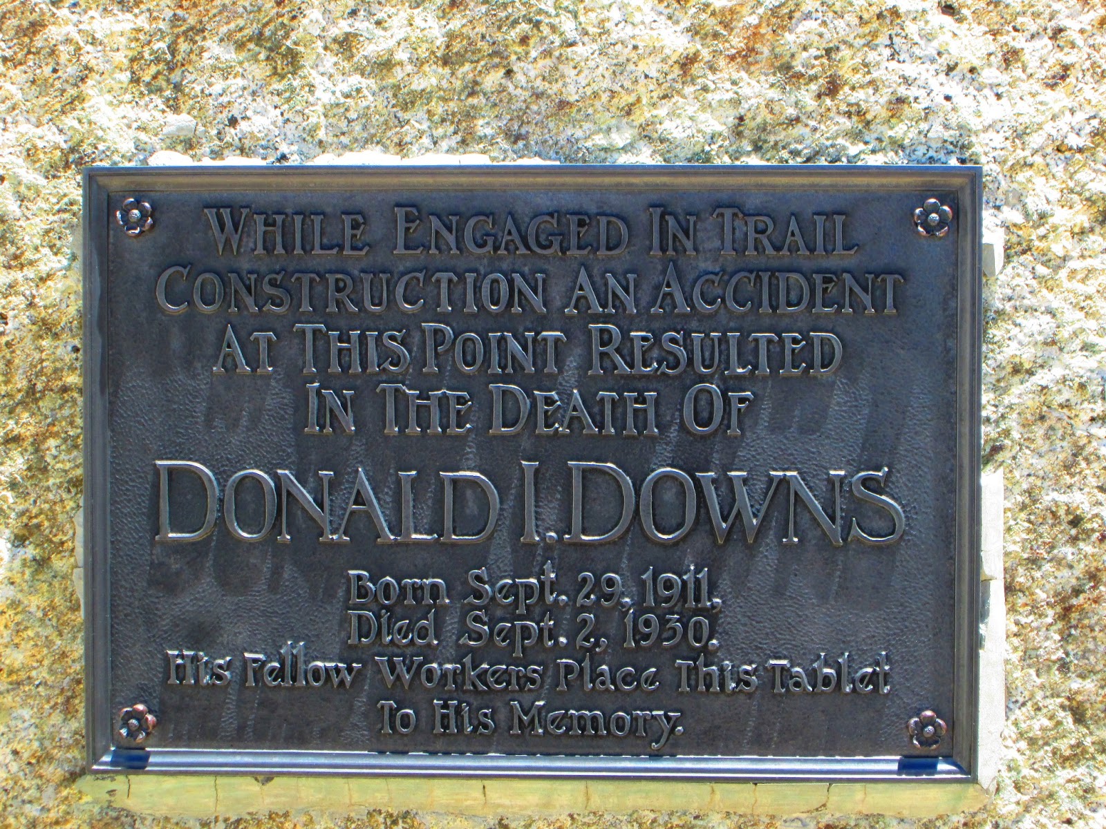 |
| The human cost to constructing trails in these mountains |
 |
| A view from the campsite at Bullfrog Lake |
Day 55 : Mt Whitney
13th June 2013
Mile 766 to mile 770 : Crabtree Meadows to Wallace creek via Mt Whitney
Mileage : 4 + 17
Today i summitted Mt Whitney, the highest mountain in the lower 48 states at 14,500 feet. The day leading up to Crabtree had been long and tough. Most people bring the mileage down in the Sierras as the terrain and elevation make hiking more difficult than usual. So the 23 miles i did made it a long day. Even so when i got to the meadows i resolved to try the sunrise hike up Mt whitney. It was an ordeal and a half to say the least. I set off from Crabtree Meadows at half past midnight having had only 3 hours sleep but in good spirits. The lid of my rucksack detaches to form a day sack, and with that filled water, food and all my warm kit, and with my sleeping bag strapped.to that in case of an emergency, i set off into the night. The sunrise hike is the classic climb for PRT hikers, as the views are spectacular. Mt Whitney is the eastern most mountain in the entire Sierra Nevada, with a phenomenal drop down to Owens Valley 10,000ft below to the east with no obstructions for tens of miles. It was too much to resist. It is 8.5 miles to the summit from Crabtree meadows climbing over 4400 feet along the way. The first few miles speed by as i made my way along the tail, occasionally glimpsing the head torches of other hikers ahead of me cutting back and forward along switchbacks. Above 12,000ft though everything went downhill, except me, who continued up the switchbacks towards the summit 2500ft farther up the trail.
What started as a dull headache quickly developed into full blown altitude sickness, getting worse with very foot i gained in altitude. By the time I got 1 mile away from the summit, i was still 500 feet below the top and had to stop. I learned later that the air is only 60% of what it is at sea level, and i could well believe it. Every 50 metres or so i had to stop and try to catch my breath, 'try' though being the operative word as even stopped my lungs and heart were working in flat out. I also felt really nauseated, and could neither drink water nor eat food. Because of this, i started to get really cold really quickly. To add to all this the was a wind that just sucked all the heat out of me, i could not stay warm. I had all my warm gear on while going up hill as fast as I could and still could not stop shivering uncontrollably. The last 2 miles of the trail to the summit wasn't particularly steep, but there was a pretty much sheer drop of over a thousand feet on the left hand side and it was when dizziness was added to my symptoms that i decided to stop, i thought it would have been too dangerous to continuous on a trail 1 foot wide with no protection whatsoever. I found a sheltered spot out of the wind and got into my sleeping bag, but even taking the sleeping bag out took a while as my fingers had gone numb in my gloves, but it was worth it. I knew that getting into my sleeping bag then meant i would miss the sunrise, but at that stage that was the least of my worries. An hour later I had warmed up considerably, i could feel my fingers again, but still couldn't eat or drink, nor were my other symptoms much improved, just as well really as my snickers were frozen to the point that i couldn't really bite them anyway, and my water bottle crunched every time i opened it with the freezing water cooling me down even more. Despite feeling so bad I decided to go for the summit, i hadn't come this far to quit from a little altitude sickness. I went up and down as quickly as possible in order to limit my exposure to further altitude and the elements, and can't have been on the summit for more than about 30 seconds, I had to get down and quickly. I didn't get out my camera, or my phone to text anyone, or update my facebook status, or drink my beer that i had brought all the way from Kennedy Meadows, didn't speak to anyone else up there, or see anyone else i knew, so have no proof that i was even there, but i did it. In hind sight perhaps i should have taken more time up there, as there were people i knew, and there was a hut in which i could have tried to warm up a bit further, but my main priority was getting down as i just felt so rubbish. 10 hours after i started i was back at Crabtree Meadows surrounded by marmots and deer recovering in the morning sun. It took me til the end of the day until i could eat anything again and before i had warmed up properly, even after having a nap in the full sun wearing all my warm kit and in my sleeping bag.
All I could think about as i sat there in the sun that afternoon looking back up at the mountain was how on earth i was going to get over Forester pass, which at 13,200 feet is the highest point on the PCT itself. Forester Pass is 13 miles from Crabtree Meadows, so finally, at about 6pm, i put on my rucksack and decided to get some miles in before the sun got too low in the sky and it started to get cold again. I knew I needed to shorten the distance so that i would be as fresh as possible when it came to going above 12,000 ft again in the morning. I went to bed finally just before hiker midnight totally exhausted after my ordeal, and not looking forward at all to the day ahead.
 |
| A view west back down towards Crabtree Meadows from somewhere high up on Mt Whitney |
 |
| One of the few pictures I took looking east from Mt Whitney, this one looking through one of the 'windows', not particularly impressive I know but it is the only proof I have that I was up there. |
Monday, 17 June 2013
Day 54 : Crabtree Meadows
12th June 2013
Mile 743 to mile 766 : Somewhere near Chicken Spring Lake to Crabtree Meadows
Mileage : 23
The objective for the day was crabtree meadows at the Mt Whitney, which I'll be climbing in the wee hours of inshallah. The idea being that be the end of today we would be in position for a sunrise ascent of Mt Whitney. The problem though was our relatively late start out from Kennedy Meadows. This was due to the fact that couple called the Eukers, who started the same day as us but whom we hadn't seen in 600 miles, we due into Kennedy Meadows in the evening of the day we were supposed to leave. While it was great ti see them, the late departure meant we didn't do as many miles as we should have done that first afternoon/evening. This in turn meant we've been playing catchup to try and get into position for Mt Whitney. Not an easy task at all. Mr Green realised he had a day's extra food and so could afford to take it slow and climb Mt Whitney 24 hours after the rest of us. For the rest of PRT this was not an option so we pushed on to Crabtree Meadows. Immediately prior to Crabtree Meadows was 1600ft climb that i was not looking forward to, but is amazing how 1200 calories can change your outlook on the day. Right before the climb i felt shattered, and was tempted to call it a day right there and climb Whitney with Mr Green and co, but the calories changed.everything. I raced up the climb in record time and before i knew it i was sitting with Pan and Dishcloth taking in the beautiful meadow, complete with its deer and marmots, and gazing up at Mt Whitney towering above us all. I arrived at Crabtree Meadows in the late afternoon thankful that i had finally arrived in the Sierra Nevada. I say that because most people consider the Sierra Nevada to start at Crabtree Meadows and not before. The preceeding 60 miles is sort of a transition zone from the low, hot, dry, deserty mountains into the real alpine wilderness of the Sierras. Infact, i saw cacti for the first 40 miles after Kennedy Meadows, and sometimes people even see rattlers so i was glad to be final 'there'. Crabtree meadows, and the other meadows the trail hits, are little tranquil oases midst the forests and bare mountain sides. Suffice to say they are simply stunning. I arrived there after a 23 mile day late in the afternoon and simply had to just stop and take it all in. The late afternoon is when the animals out to the meadows to feed, and today was no exception. I sat watching mule deer emerging from the forest and stand in the middle of meadows searching for that perfect piece of grass. They stand right in the middle of meadows, which can often be pretty big, in order that they have a 360 view around them, and thus cant be surprised by bears, mountain lions or hikers. The deer seemed totally relaxed around hikers, they clearly know we're not a threat, but i've read that they can be quite dangerous. Indeed I read somewhere that deer kill more people per year in the states than bears, as people try to feed them and then get slashed/boxed by deer whose hooves are honed razor sharp from the granite slabs of the mountains. Along with the mule deer the other most abundant animal is the marmot. The easiest way to describe a marmot is to say they are a very fat ground squirrel with meerkat tendencies. They live amongst the boulders and emerge in the morning and evening standing up on their hind legs surveying the landscape. They, like the muledeer are totally unafraid of hikers but should not be approached as they can carry parasites and spread diseases if they bight you. From my basking spot in Crabtree Meadows I could see all the way up to the top of Mt Whitney, and decided there and then that I would climb in time to see tomorrows sunrise.
 |
| Mule deer in Crabtree Meadows |
 |
| Mt Whitney from Crabtree Meadows, the peak is right above my head |
Day 53 : 9000+feet
11 June 2013
Mile 721 to mile 743 : Olancha Trail Junction to somewhere just before Chicken Spring Lake
Mileage : 22
Pan, Mr green and i camped together last night, the other 2 pushed on for another half a mile or so looking for a better spot. Even though all my food was not in my bear canister the first night in the Sierras thankfully past without event, the wind died as we went to bed, and our bear canisters didn't get put to the test. I did however sleep with my hiking poles close to hand ready to fight any marauding bear trying his luck during the night. The first half of the day was spent finishing the climb we started yesterday, and then descending to a meadow for lunch. Just before the stop Starfox, an Aussie who is now paired up with Chick-Chack, one of the Oregon trio, pointed out a carving on a tree trunk of a man smoking a pipe with some unintelligible initials above. His guide book said it was carved by Basque shepherds passing through the area in the middle.of the 19th century, when the west of the US was first being settled. It was pretty cool to see something that old, well, old for the USA at least. After lunch the 2nd climb began leading back up to 10,500 feet. I have been looking at the elevation profiles for the coming days and weeks, and it doesn't look like we'll be back below 9000ft until after Tuolumne meadows (excepting descents out of the mountains at resupply points) and infact will be spending a significant period of those weeks above 11,000ft. The elevation is definitely having an effect on me, i tire more quickly than usual and have to stop to catch my breath more often on the approaches to summits. At this stage we've all reached a high level of fitness, with none of us being particularly stronger or weaker than anyone else, but it seems that the altitude is affecting me more than anyone else, so am the slowest at the moment. Towards the end of the day the trail gave me one of the most impressive views so far, which is saying something for the PCT. Although the PCT passes through Sequoia, Kings Canyon, and Yosemite national parks in sequence, it really only passes through the easternmost edges. From west to east the Sierras rise slowly up to their highest sections in the south eastern segment before plunging almost vertically down into the Owens Valley, which runs north south separating the Sierras from the desert mountains ranges around Death Valley. The view that I had in that late afternoon was similar to that from Mt Jacinto, with a vertical drop of about 7000ft, it was incredible.
 |
| The Basque shepherd's carving |
 |
| The view down to Owens Valley |
 |
| The Sierras are full of this type of tree (a cedar I think) that grows in a helix, I have never seen anything like it. Can anyone why a tree would want to do this? |
Day 52 : Climbing into the mountains
10th June 2013
Mile 704 to mile 721 : Kennedy Meadows Campground to Olancha Trail Junction
Mileage : 17
The climb into the Sierras began today, and itt was great. As soon as the climb began it began to feel cool, and i haven't felt a cool breeze in days. If the air is cool, and if there is a breeze, i can climb easily. Even with the sun, the monstrous bear canister, 7 days of food and Cinderella weighing me down the first 2000ft climb went by in no time. After the first climb the trail reaches a meadow like plateau through which the kern river meanders. After lunch by the river and a spot of basking in the sun the second climb began, 1500 ft later we called it day at an altitude of about 9500ft. We could all easily have gone farther given that it was the first day out from a rest stop but there was no need. The climb from here goes up to over 10,500ft before descending again 9000ft to a river crossing. The 10 miles between here and the river crossing is the last waterless stretch of Southern California, a whole 10 miles! This means that from now on i will only be carrying 2 litres of water at a time, maximum. That alone is going to make life so much easier. The change in temperature is also going to make life a whole lot easier. During the last week from Tehachapi pretty much every meal was a chore to eat, but now i feel my appetite returning, and a good thing too. The hiking is going to be more difficult with the increased elevation so i am trying to eat more to compensate but of course this though comes with the added challenge of carrying more weight. I'm carrying so much food now that it won't all fit in the bear canister, so I'll be trying to eat my most heavy and bulky food first so that I don't attract too many bears.
 |
| From left to right : Dishcloth, Mr Green and Me |
 |
| The bridge over the river Kern |
Sunday, 9 June 2013
Day 51 : Sierra Nevada here I come
9th June 2013
Mile 702 to Mile 712 : Kennedy Meadows to Somewhere higher up than here
Mileage : 10
Today the Sierra Nevada begins. I have spent the better part of the day getting my kit in order in preparation for an evening departure. In the next 10 miles I'll be ascending 2000 feet, and the next morning, another 3000 almost, so inshallah for the next 200 miles hiking through the day will be a possibility which will be a real change for the better.
As we progress into the mountains, there will be a shift in the logistical challenge of carrying lots of water, to carrying lots of food, at least 7 days for this next stretch, and a bear canister for it all to go in. For those hikers that are arriving from abroad, and will need the bear canister for the month it will take to get through the mountains, a loaner program has been set up and once I picked mine up from Tom's I set about playing tetris will all my food in an attempt to get it all to fit. As the picture shows i was unsuccessful. Technically for the first 2 days or so a bear canister is not required so i can carry an eat 2 days worth of food and not need for it all to go in there. That being said it is high advised for all food to be secured either in a canister, or in a bear box located at a campsite. There is a trail myth this year about a girl who didn't have all her food in a canister and decided the best place to store the rest would be in a stuff sack she was using as a pillow, counting on the fact that a bear would not be so bold as to approach a human. A very unwise decision as it turned out. She awoke in the middle of the night to discover a bear gently pulling the stuff sack out from under her head with its teeth. Whether or not this particular tale is true does not change the fact the bears around here can be very aggressive when it comes to food and you always have to remember the odds are not in your favour should you decide to defend your food. Another tale i got first hand from elderly local at Kennedy Meadows General Store was that he once awoke to discover a bear rocking him gently back and forward in his sleeping bag in an attempt to roll him off his rucksack in which was stored all his food. He said that he decided to pretend to asleep and thus not surprise, and therefore potentially provoke, the bear and rolled off the rucksack and let the bear have the food. The morning light showed that the sleeping bag had mostly survived the bear rocking and was surprsingly, the rucksack though was not so fortunate and was shredded completely. All this goes to show that bears do not target humans, but the food that we carry, so I most certainly will not be sleeping with my food and will instead leave it well away from whereever i am sleeping.
The next updates will probably be in 7 days time, hope you all check back then!
Day 50 : A full zero At Kennedy Meadows
8th June 2013
No Miles
Mileage : 0
Today was a full zero in Kennedy Meadows. There is little to be said about today except that it consisted of much resting. It is still very hot, approaching 33 degrees in the shade, and much much more in the sun, so most of the day was spent playing musical shadows with trees and other shade providers, but it was a good day anyway.
 |
| Kennedy Meadows General Store |
Day 49 : Nero in Kennedy Meadows
Friday 7th 2013
Mile 798 to mile 702 : Kern river to Kennedy Meadows
Mileage : 4
Today I arrived at Kennedy Meadows proper, and what a god send it was to finally get there. I know I said in my last post that i was done with SoCal yesterday, but infact Pan and I stopped a few miles short in order to get one night of decent sleep and not get sucked into drinking beer late into the night catching up with other hikers. I definitely made the right decision. I woke up feeling fresh for the first time
in over a week, glad that there was no need to be up and make miles before the heat of the day. When Pan and I finally did get on the move the 4 miles pretty much flew by, and before I knew it we had arrived at Kennedy Meadows.
Kennedy Meadows consists of 2 and only 2 establishments : the General Store and Tom's Internet Cafe. Between these two places there is everything one needs to rest up and prepare for the Sierra Nevada. The Sierra Nevada will hopefully be as far removed from the desert sections as possible. There will be real mountains with snow on them, rivers and lakes everywhere, wildlife, and best of all, cool air thanks to the higher elevations. But before all that I will be taking a zero or two to let the body recover from the ordeal that was Section F.
Thanks to Aloha, myself, Pan & Kat sent into Ridgecrest to try and find somewhere to use the internet and buy some beer for Dishcloth's birthday, who is turning 33 tomorrow. On the approach to Ridgecrest, which is about an hour away KM by car, we stopped at a tiny petrol station with a small convenience store attached. In this little convenience I found, to my incredible surprise, an amazing selection of english ales ripe for the picking (see photo). Why a nondescript little shop in a nondescript little town in a nondescript part of the Mojave desert should be stocking Boddingtons, Hobgoblin, London Pride and the like is beyond me. But i most certainly appreciated it. There was even a Wychwood beer called Scarecrow that i'd never heard of, but was nevertheless delicious. Dishcloth is partial to ales, so I bought a healthy selection for us to sample together, and after taking on some calories we piled back into the car and went back up the road to KM. Another objective of the trip to Ridgecrest was to buy some presents for Dischcloth. Although i doubt there was an intentional sabotage, the Union flag that I carefully crafted in Tehachapi did not even make it out of the car that took him back to the trail head to start last weeks hike. This means that Dishcloth, unlike most of the rest of PRT, has not been carrying a stupid present for the last 140 miles like the rest of us have been doing. For his birthday, Dishcloth received a stunning piece of hiker apparel in the form of a peach coloured summer skirt, a WWF wrestling belt that will have to be strapped to his pack along with everything else, and a miniature fan that he will have to carry heavy batteries for should he wish to use it. Pictures of Dishcloth and his presents to be uploaded shortly.
Mile 798 to mile 702 : Kern river to Kennedy Meadows
Mileage : 4
Today I arrived at Kennedy Meadows proper, and what a god send it was to finally get there. I know I said in my last post that i was done with SoCal yesterday, but infact Pan and I stopped a few miles short in order to get one night of decent sleep and not get sucked into drinking beer late into the night catching up with other hikers. I definitely made the right decision. I woke up feeling fresh for the first time
Kennedy Meadows consists of 2 and only 2 establishments : the General Store and Tom's Internet Cafe. Between these two places there is everything one needs to rest up and prepare for the Sierra Nevada. The Sierra Nevada will hopefully be as far removed from the desert sections as possible. There will be real mountains with snow on them, rivers and lakes everywhere, wildlife, and best of all, cool air thanks to the higher elevations. But before all that I will be taking a zero or two to let the body recover from the ordeal that was Section F.
Thanks to Aloha, myself, Pan & Kat sent into Ridgecrest to try and find somewhere to use the internet and buy some beer for Dishcloth's birthday, who is turning 33 tomorrow. On the approach to Ridgecrest, which is about an hour away KM by car, we stopped at a tiny petrol station with a small convenience store attached. In this little convenience I found, to my incredible surprise, an amazing selection of english ales ripe for the picking (see photo). Why a nondescript little shop in a nondescript little town in a nondescript part of the Mojave desert should be stocking Boddingtons, Hobgoblin, London Pride and the like is beyond me. But i most certainly appreciated it. There was even a Wychwood beer called Scarecrow that i'd never heard of, but was nevertheless delicious. Dishcloth is partial to ales, so I bought a healthy selection for us to sample together, and after taking on some calories we piled back into the car and went back up the road to KM. Another objective of the trip to Ridgecrest was to buy some presents for Dischcloth. Although i doubt there was an intentional sabotage, the Union flag that I carefully crafted in Tehachapi did not even make it out of the car that took him back to the trail head to start last weeks hike. This means that Dishcloth, unlike most of the rest of PRT, has not been carrying a stupid present for the last 140 miles like the rest of us have been doing. For his birthday, Dishcloth received a stunning piece of hiker apparel in the form of a peach coloured summer skirt, a WWF wrestling belt that will have to be strapped to his pack along with everything else, and a miniature fan that he will have to carry heavy batteries for should he wish to use it. Pictures of Dishcloth and his presents to be uploaded shortly.
 |
| London Pride, Bombardier, Double Chocolate Stout, Boddingtons, Hobgoblin and Spitfire to name but a few of the bizarely good selection of english ales to be had in Ridgecrest |
 |
| Boddingtons, the Cream of Manchuria |
Saturday, 8 June 2013
Day 48 : The end of Southern California
6th June 2013
Mile 676 to mile 698 : The second last hill before KM to the Kern river
Mileage : 22
Today was the last day of Southern California!
It was another very early start after not much sleep as i tried to get the last climb of the Southern California section of the PCT done before the heat. The day was mostly uneventful except for the fact that i finished Southern California today! Have i mentioned it enough yet? Probably not. I am.done with SoCal as of this evening! Woohoo! The end could not have come any sooner. The last 140 miles from Tehachapi have been especially difficult and mostly enjoyable. As i have said many times this is almost entirely due to the heat. It was been extremely challenging to say the least. It is jot only the heat that makes hiking difficult, it is everything that that entails. The early mornings and late nights mean it is not not possible to get enough sleep. Although in theory there is lots.of free time during the long break in between in which to sleep, it is usually too hot to sleep so most of the time i am very fatigued. The heat also has a massive effect on my appetite. I find that i have almost none, which is not good. The hiker hunger has definitely kicked in, meaning most of my fat reserves are now gone therefore i have to eat huge amounts just to be able to do the miles and not waste away. This has been a major challenge of the desert sections, and one i won't miss as the trail climbs high into the Sierra Nevada.
All these combine to make the hiking through the desert sections pretty miserable at times, and in particular during this last week.But its not all bad, far from it. I have been amazed at the variety of geography, geology, flora and fauna in Southern California, and especially the rate at which it changes, even on foot going at 3 miles an hour. On more than one occasion i went from blisteringly hot desert with rattlesnakes, scorpions, cacti and tumbleweeds to cool shady pine forests high up above the desert floor complete with bears, mountain lions and nights so cold my water bottles turn to ice overnight. It has been varied in the extreme, and it has been amazing.
Natural elements aside for a moment, the trail thus far would not have been half as incredible as it has been without the people on it. Loosely, people on the trail fall into one of 3 categories : other PCT hikers, trail angels, and trail town locals, and they have all been amazing. I usually hike with about 5 other people most of the time. We are all incredibly different apart from the fact that we are all on the trail. And because we're on the trail all the other differences are irrelevant. We all go through exactly the same hardships day in and day out, all experience the same highs and lows, and all enjoy sharing this adventure with each other, inspire of our differences. Apart from the guys i hike with all the time, there are another 15 or so that are on the periphery, as it were. These are hikers with slightly different speeds and styles, meaning i might only see them every few days or so, but when do it's like greeting old friends. Decidedly odd given that i know so little about most of them, but none of that seems to matter out here, we all just get along. The trail angels have been equally incredible if not more so. What they do is hard to describe, why they do it even harder. Most, but not all of them, are ether former or aspiring thru-hikers and enjoy the community that surrounds the trail so much the they provide magic up and down the trail. Some are spontaneous, others established. Funsize had an experience where he turned up at a campsite just as 2 angels were leaving. They angel 1 day a year and bizarrely no-one had showed up so they were leaving. He got a full meal complete with wine, a bed in their campervan, and breakfast the next morning. Other angels keep water caches stocked up in crucial locations throughout the hiking season, and these caches are worth their weight in gold. I'd like to think i could have not used these caches, and relied only on natural sources, but it would have made life much more difficult especially in a very hot year such as this one and would have required a great deal of night hiking. I can't emphasise enough just how incredible these guys are. Last but not least are the locals in the trail towns through which we pass. Small town America is great, and so different to an equivalent town in France or the UK so it's great to see them as see a partook America most people don't usually get to see.
Mile 676 to mile 698 : The second last hill before KM to the Kern river
Mileage : 22
Today was the last day of Southern California!
 |
| 700 miles! |
All these combine to make the hiking through the desert sections pretty miserable at times, and in particular during this last week.But its not all bad, far from it. I have been amazed at the variety of geography, geology, flora and fauna in Southern California, and especially the rate at which it changes, even on foot going at 3 miles an hour. On more than one occasion i went from blisteringly hot desert with rattlesnakes, scorpions, cacti and tumbleweeds to cool shady pine forests high up above the desert floor complete with bears, mountain lions and nights so cold my water bottles turn to ice overnight. It has been varied in the extreme, and it has been amazing.
Natural elements aside for a moment, the trail thus far would not have been half as incredible as it has been without the people on it. Loosely, people on the trail fall into one of 3 categories : other PCT hikers, trail angels, and trail town locals, and they have all been amazing. I usually hike with about 5 other people most of the time. We are all incredibly different apart from the fact that we are all on the trail. And because we're on the trail all the other differences are irrelevant. We all go through exactly the same hardships day in and day out, all experience the same highs and lows, and all enjoy sharing this adventure with each other, inspire of our differences. Apart from the guys i hike with all the time, there are another 15 or so that are on the periphery, as it were. These are hikers with slightly different speeds and styles, meaning i might only see them every few days or so, but when do it's like greeting old friends. Decidedly odd given that i know so little about most of them, but none of that seems to matter out here, we all just get along. The trail angels have been equally incredible if not more so. What they do is hard to describe, why they do it even harder. Most, but not all of them, are ether former or aspiring thru-hikers and enjoy the community that surrounds the trail so much the they provide magic up and down the trail. Some are spontaneous, others established. Funsize had an experience where he turned up at a campsite just as 2 angels were leaving. They angel 1 day a year and bizarrely no-one had showed up so they were leaving. He got a full meal complete with wine, a bed in their campervan, and breakfast the next morning. Other angels keep water caches stocked up in crucial locations throughout the hiking season, and these caches are worth their weight in gold. I'd like to think i could have not used these caches, and relied only on natural sources, but it would have made life much more difficult especially in a very hot year such as this one and would have required a great deal of night hiking. I can't emphasise enough just how incredible these guys are. Last but not least are the locals in the trail towns through which we pass. Small town America is great, and so different to an equivalent town in France or the UK so it's great to see them as see a partook America most people don't usually get to see.
 |
| Finally a view of the Sierra Nevada, with snow on them even! I can't wait to be there |
 |
| This is an incredible picture taken by Peter Pan of a rattlesnake in strike position |
 |
| The same snake with rattle in action |
Day 47 : Uranium Spring
5th June 2013
Mile 651 to mile 676 : Walker Pass Campground to the second hill climb before Kennedy Meadows.
Mileage : 25
This time it was our turn to be up early, or at least Pan and i were. Both of us struggle in the heat, more so than the others it seems so we set off early to at least get the climbs done before the heat set in.
We managed to get into the water source just after 11am, and proceeded to wait out the sun. The spring we were at is called the Joshua tree spring. The Joshua tree is ostensibly a desert tree (although I'm not sure it is actually a tree strictly speaking) and it annoyed me to see it around the spring as we should really be approaching the high mountains by now an not be seeing cacti, Joshua trees, rattlesnakes or anything else of hat ilk, but clearly the desert doesn't want to let go of us just yet it would seem. According to the locals the spring has another unofficial name : Uranium spring, as it is apparently is found in the water. I was skeptical though it must be said. Over the next hour or so the area found the spring filled up with other hikers all escaping the heat. We all tried to get some sleep, knowing that in order to compensate for having taken several hours off during the day we must hike long into the night, but even with the shade it was too hot to sleep. Finally though it was cool enough to carry on, and off we went into the evening. 6 hours later saw me camping on my own having lost the others in the night and trying not to think about bears as i went to sleep.
A pair of hikers about half an hour ahead had had a run in with a cub ambling along the trail. While cubs themselves pose no threat, the still scare people as cubs are never alone. One small yelp from the cub having spotted a smelly hiker is enough to bring mum crashing through the woods at high speed to come to the rescue of her cub. If you have the misfortune to be between mother and child you are in big, big trouble. It is about the only situation in which you have a really chance of being killed by a bear. Apart from the aforementioned situation black bears especially do not pose a real problem, except for the fact that they will steal your food if they can. In the next section bear canisters are required to prevent bears from getting at food. Just what i need, the extra kilo to added my rucksack along with the 7 days of food I'll be carrying is going to make the hiking difficult, difficult, lemon difficult. With all this going through my mind i fell asleep grateful of the few hours sleep before the next early start tomorrow.
 |
| This thirsty guy clearly wanted to drink at the spring, but was too spooked by all us hikers |
Subscribe to:
Comments (Atom)